Categories
AutoCAD How To Guides

Mastering the PURGE Command in AutoCAD: A Comprehensive Guide

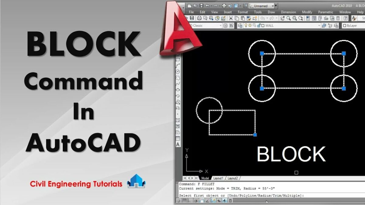
AutoCAD, the industry-leading computer-aided design (CAD) software developed by Autodesk, offers a multitude of tools and commands for creating precise and detailed drawings. Among these tools, the PURGE command stands out as a fundamental feature for optimizing drawing files by removing unused or redundant elements. In this comprehensive guide, we delve deep into the intricacies of using the PURGE command in AutoCAD, exploring various methods, techniques, and best practices for optimal utilization.

Understanding the PURGE Command in AutoCAD:

The PURGE command in AutoCAD allows users to clean up drawing files by removing unused or redundant objects, such as layers, blocks, linetypes, and dimension styles. It is a powerful tool for reducing file size, improving performance, and streamlining workflows by eliminating clutter and optimizing drawing efficiency. The PURGE command enables users to maintain drawing integrity and optimize resources by removing unnecessary elements that may accumulate during the design process.

Using the PURGE Command:

AutoCAD offers multiple methods for using the PURGE command to clean up drawing files:

1. Command Line Input:

The most straightforward method for using the PURGE command is through command line input. To clean up drawing files using the command line, follow these steps:

  1. Type “PURGE” in the command line and press Enter to activate the PURGE command.
  2. Select the type of object you want to purge, such as blocks, layers, linetypes, or dimension styles, from the list of purgeable items.
  3. Press Enter to remove unused objects of the selected type from the drawing.

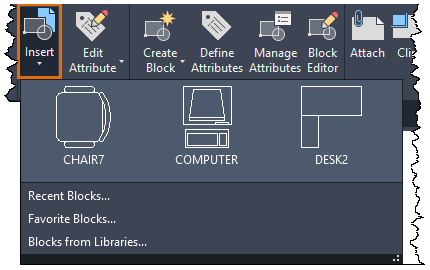
2. Ribbon Interface:

AutoCAD’s Ribbon interface provides a graphical user interface for accessing commands and tools. To use the PURGE command from the Ribbon interface, follow these steps:

  1. Navigate to the Home tab on the Ribbon.
  2. Click on the Modify panel to expand it.
  3. Click on the Purge icon to activate the PURGE command.
  4. Select the type of object you want to purge from the Purge dialog box.
  5. Click the Purge All button to remove all unused objects of the selected type, or select individual items to purge.
  6. Click OK to complete the purging operation.

3. Toolbar or Tool Palette:

Users can also access the PURGE command from toolbars or tool palettes for quick access and convenience. Simply click on the Purge tool icon in the toolbar or tool palette to activate the PURGE command and follow the prompts to clean up drawing files.

Key PURGE Command Options:

When using the PURGE command in AutoCAD, users can specify various options and parameters to customize the purging operation according to their requirements. Key options include:

  1. Purge All: Remove all unused objects of the selected type from the drawing, streamlining the purging process for comprehensive cleanup.
  2. Selective Purge: Select individual items to purge from the drawing, allowing for targeted removal of specific objects or elements.
  3. Purge Nested Items: Optionally, enable the purge nested items option to remove nested objects or dependencies along with the selected objects, ensuring thorough cleanup and optimization.

Advanced Techniques:

In addition to basic purging methods, AutoCAD offers advanced techniques and tools for enhancing the PURGE command and efficiency:

  1. Audit and Repair: Use the AUDIT command in conjunction with the PURGE command to detect and repair drawing errors or inconsistencies before purging, ensuring drawing integrity and stability.
  2. Purge Registered Applications: Enable the purge registered applications option to remove unused objects associated with third-party applications or custom components, optimizing drawing performance and compatibility.
  3. Purge Unused Layers with LayDel: Utilize the LayDel (Layer Delete) command to purge unused layers along with their associated objects, providing a comprehensive solution for layer cleanup and optimization.

Best Practices:

To achieve optimal results when using the PURGE command in AutoCAD, it’s essential to adhere to the following best practices:

  1. Regular Maintenance: Incorporate purging into your regular drawing maintenance routine to prevent accumulation of unused objects and ensure drawing file efficiency.
  2. Review and Preview: Before purging, carefully review the list of unused objects and preview the impact of the purging operation to avoid unintentional deletion of critical elements.
  3. Backup and Versioning: Always create backup copies of drawing files before purging to safeguard against data loss or unintended changes, and maintain version control for traceability and accountability.
  4. Document Changes: Document and communicate changes made through the purging process to collaborators or stakeholders to ensure transparency and avoid misunderstandings.

Conclusion:

In conclusion, mastering the PURGE command in AutoCAD empowers designers and drafters to optimize drawing files with precision and efficiency. By understanding the various methods, options, and best practices for using the PURGE command, users can streamline workflows, improve performance, and maintain drawing integrity. With AutoCAD’s versatile tools and features, designers can achieve efficient cleanup and optimization of drawing files, enhancing productivity and collaboration in their projects.

Categories
AutoCAD How To Guides

Navigating the Nexus: Leveraging Project Drawings for Location and Data Queries in AutoCAD

Introduction:

AutoCAD, a venerable name in the realm of Computer-Aided Design (CAD), transcends its drafting roots by incorporating robust features that extend beyond geometry. Among these capabilities, the integration of project drawings for location and data queries stands as a transformative force. This extensive guide delves into the intricacies of leveraging project drawings in AutoCAD, exploring how location-based information and data queries elevate the utility of drawings, streamline decision-making, and enhance collaboration.

Section 1: The Evolution of Location-Based Design

1.1 From Static Drawings to Dynamic Data: Explore the evolution of design methodologies, highlighting the shift from traditional, static drawings to dynamic, location-based designs. Understand how AutoCAD, through the incorporation of geographic information, transforms drawings into comprehensive databases with a spatial context.

1.2 Significance of Location-Based Design: Delve into the significance of location-based design in AutoCAD. From urban planning and infrastructure development to environmental analysis, this approach provides a spatial understanding that is crucial for decision-making and collaboration across diverse industries.

Section 2: Enabling Location in AutoCAD Drawings

2.1 Geographic Coordinate Systems: Master the integration of geographic coordinate systems in AutoCAD. Explore how setting up the correct coordinate system aligns drawings with real-world locations, facilitating accurate spatial representation within the AutoCAD environment.

2.2 Incorporating GIS Data: Learn the process of incorporating Geographic Information System (GIS) data into AutoCAD drawings. Understand how GIS data, such as maps and satellite imagery, enriches project drawings with contextual information, providing a comprehensive spatial backdrop.

Section 3: Using Location Tools in AutoCAD

3.1 Geolocation and Live Maps: Explore the Geolocation feature in AutoCAD. Learn how to use live maps to georeference drawings, enabling dynamic updates based on real-world changes and providing an accurate spatial foundation for design decisions.

3.2 Site Planning and Analysis: Master the art of site planning and analysis in AutoCAD. Understand how location-based tools empower designers to analyze topography, solar exposure, and other site-specific factors, fostering informed decision-making during the design process.

Section 4: Leveraging Location-Based Queries

4.1 Location-Specific Data Queries: Delve into the integration of location-specific data queries in AutoCAD. Explore how to query and extract information based on spatial parameters, providing a dynamic and context-aware approach to data analysis within project drawings.

4.2 Spatial Data Analysis: Learn how to perform spatial data analysis within AutoCAD. Understand how location-based queries facilitate tasks such as proximity analysis, spatial filtering, and spatial aggregation, allowing for a deeper understanding of the design context.

Section 5: Geo-Fencing and Design Constraints

5.1 Implementing Geo-Fencing: Explore the implementation of Geo-Fencing in AutoCAD. Understand how this feature allows users to define virtual boundaries within drawings, triggering notifications or constraints based on spatial criteria, ensuring design compliance.

5.2 Design Constraints and Location Parameters: Master the use of design constraints based on location parameters. Explore how AutoCAD enables designers to set location-specific restrictions or requirements, ensuring that designs align with regulatory, environmental, or contextual considerations.

Section 6: Associating Non-Spatial Data with Location

6.1 Embedding Non-Spatial Data: Learn how to embed non-spatial data within the spatial context of AutoCAD drawings. Understand the process of associating information such as project details, materials, or specifications with specific locations, creating a comprehensive and interconnected dataset.

6.2 Data Linking and External Databases: Explore the integration of external databases with location-specific data in AutoCAD. Understand how to link database tables to drawing entities, ensuring that non-spatial data is dynamically linked to the spatial context, providing a holistic view of project information.

Section 7: Collaborative Workflows with Location-Based Design

7.1 Collaborating with Geographic Context: Explore best practices for collaborating with team members in a location-based design environment. Understand how shared geographic context enhances communication, facilitating collaboration on design decisions, and ensuring a unified understanding of project locations.

7.2 Cloud-Based Collaboration: Discover the collaborative potential of cloud-based platforms in location-based design. Explore how connecting AutoCAD drawings to cloud services facilitates real-time collaboration, allowing multiple users to access, update, and contribute to the project’s spatial information.

Section 8: Challenges and Troubleshooting

8.1 Common Challenges in Location-Based Design: Address common challenges encountered when working with location-based design in AutoCAD. From issues with coordinate systems to challenges in integrating GIS data, gain insights into effective problem-solving strategies.

8.2 Troubleshooting Tips: Explore troubleshooting tips for resolving issues related to location-based design in AutoCAD. From verifying coordinate system settings to addressing conflicts with external data links, understand how to maintain precision and stability in your design process.

Section 9: Future Trends and Emerging Technologies

9.1 Augmented Reality (AR) for Spatial Visualization: Delve into the potential integration of augmented reality (AR) with location-based design in AutoCAD. Explore how AR technologies enhance the immersive experience of interacting with spatially contextualized designs in real-world contexts.

9.2 Internet of Things (IoT) Integration: Explore the integration of Internet of Things (IoT) in location-based design. Learn how IoT sensors and devices can contribute real-time data to AutoCAD drawings, creating a dynamic and responsive environment for design decisions.

Conclusion:

As we conclude this exhaustive exploration of leveraging project drawings for location and data queries in AutoCAD, it is evident that the integration of geographic information transforms design workflows. By embracing location-based design principles, AutoCAD users can create dynamic, context-aware drawings that provide a spatial understanding crucial for decision-making across various industries. Embrace the versatility, efficiency, and customization that AutoCAD offers in leveraging location information, and witness how this transformative skill elevates your designs from mere drawings to intelligent, location-specific assets. With continuous practice, exploration, and innovation, you will navigate the intricate landscape of location-based design in AutoCAD with confidence, producing designs that stand as testaments to the power of CAD in the dynamic world of design and engineering.

Categories
AutoCAD How To Guides

Bridging the Gap: Connecting Databases to AutoCAD for Enhanced Functionality and Data-Driven Design

Introduction:

AutoCAD, a powerhouse in the realm of Computer-Aided Design (CAD), is renowned for its versatility in creating precise and detailed drawings. However, the integration of databases with AutoCAD introduces a transformative dimension, enabling users to move beyond static drawings to dynamic, data-driven designs. This extensive guide explores the intricacies of connecting databases to AutoCAD, shedding light on the enhanced functionality, improved collaboration, and data-driven decision-making that this integration facilitates.

Section 1: Understanding the Intersection of Databases and AutoCAD

1.1 The Evolution of Data-Driven Design: Explore the evolution of design methodologies, moving from traditional, static drawings to dynamic, data-driven design. Understand the paradigm shift that occurs when databases are seamlessly integrated with AutoCAD, enriching drawings with live, up-to-date information.

1.2 Significance of Database Integration: Delve into the significance of connecting databases to AutoCAD. From streamlining data management to enhancing collaboration and decision-making, this integration offers a myriad of benefits that elevate the capabilities of AutoCAD beyond traditional drafting.

Section 2: Types of Databases Compatible with AutoCAD

2.1 Relational Databases: Explore the compatibility of AutoCAD with relational databases such as MySQL, Microsoft SQL Server, and Oracle. Understand how relational databases organize and manage data, providing a structured framework for seamless integration with AutoCAD.

2.2 Spatial Databases: Delve into the compatibility of AutoCAD with spatial databases like PostgreSQL with PostGIS extension. Understand how spatial databases enhance AutoCAD’s capabilities by incorporating geographic information, enabling the creation of maps, and supporting location-based design.

2.3 NoSQL Databases: Explore the integration of AutoCAD with NoSQL databases like MongoDB. Understand how the flexibility of NoSQL databases accommodates unstructured data, offering diverse possibilities for storing and retrieving information within AutoCAD.

Section 3: Setting Up Database Connections in AutoCAD

3.1 Data Link Manager: Master the use of Data Link Manager in AutoCAD. Explore how this tool facilitates the establishment of connections between AutoCAD drawings and external databases, ensuring seamless data flow and real-time updates.

3.2 Configuring ODBC Connections: Learn the process of configuring Open Database Connectivity (ODBC) connections in AutoCAD. Understand how ODBC acts as a bridge between AutoCAD and various database management systems, enabling efficient data exchange.

Section 4: Associating Database Tables with AutoCAD Objects

4.1 Object Data and Custom Properties: Explore the use of object data and custom properties in AutoCAD. Understand how these features allow users to associate database tables with AutoCAD objects, enriching drawings with additional attributes such as materials, costs, and specifications.

4.2 Attaching External Data to AutoCAD Objects: Delve into the process of attaching external data to AutoCAD objects. Learn how to link database tables with drawing entities, ensuring that changes in the database are reflected in the drawing and vice versa.

Section 5: Extracting and Reporting Data from AutoCAD

5.1 Data Extraction Wizard: Master the Data Extraction Wizard in AutoCAD. Explore how this tool empowers users to extract specific data from drawings and associated databases, creating customized tables and reports that enhance data analysis.

5.2 Generating Reports: Learn how to generate reports from extracted data in AutoCAD. Understand the flexibility of creating tabular representations of data, allowing for better visualization, analysis, and presentation of information.

Section 6: Dynamic Data Linking and Live Updates

6.1 Dynamic Data Linking: Delve into dynamic data linking in AutoCAD. Explore how this feature enables a live connection between drawings and databases, ensuring that changes in the database are reflected in real-time within the AutoCAD environment.

6.2 AutoCAD Fields and Database Links: Master the use of AutoCAD fields to establish database links. Understand how AutoCAD fields provide dynamic placeholders for database information, fostering a connection that automates data updates and enhances drawing accuracy.

Section 7: Advanced Techniques for Database Integration

7.1 Parametric Design with Database Integration: Explore the concept of parametric design in AutoCAD through database integration. Learn how to establish parameters that dynamically respond to changes in database values, allowing for adaptive and responsive design.

7.2 Spatial Queries and GIS Integration: Delve into spatial queries within AutoCAD through GIS (Geographic Information System) integration. Understand how this advanced technique enables users to perform spatial analyses, query spatial data, and visualize geographic information seamlessly.

Section 8: Collaborative Workflows with Database Integration

8.1 Collaborating with Team Members: Explore best practices for collaborating with team members when databases are integrated into AutoCAD. Understand how shared databases enhance team collaboration, providing a centralized repository for project data.

8.2 Cloud-Based Collaboration: Discover the collaborative potential of cloud-based platforms in AutoCAD. Explore how connecting databases to cloud services facilitates real-time collaboration, allowing multiple users to access, update, and contribute to the project data.

Section 9: Challenges and Troubleshooting

9.1 Common Challenges in Database Integration: Address common challenges encountered when integrating databases with AutoCAD. From data consistency issues to challenges in establishing and maintaining database connections, gain insights into effective problem-solving strategies.

9.2 Troubleshooting Tips: Explore troubleshooting tips for resolving issues related to database integration in AutoCAD. From verifying database connections to addressing conflicts with data extraction, understand how to maintain precision and stability in your design process.

Section 10: Future Trends and Emerging Technologies

10.1 Machine Learning and Predictive Analysis: Delve into the potential integration of machine learning and predictive analysis in AutoCAD through database connections. Explore how AI algorithms may assist in analyzing historical data, predicting future trends, and optimizing design decisions.

10.2 Virtual Reality (VR) and Database Visualization: Explore the integration of virtual reality (VR) with AutoCAD and database visualization. Learn how VR technologies enhance the immersive experience of interacting with data-rich designs in real-world contexts.

Conclusion:

As we conclude this exhaustive exploration of connecting databases to AutoCAD, it is evident that the integration of data introduces a new frontier in design and engineering. By seamlessly connecting databases, AutoCAD evolves from a drafting tool to a dynamic, data-driven platform that fosters collaboration, enhances decision-making, and streamlines workflows. Embrace the versatility, efficiency, and customization that AutoCAD offers in connecting databases, and witness how this transformative skill elevates your designs from static drawings to intelligent, information-rich assets. With continuous practice, exploration, and innovation, you will navigate the intricate landscape of database integration in AutoCAD with confidence, producing designs that stand as testaments to the power of CAD in the dynamic world of design and engineering.